DEC Launches New ‘DECinfo Locator’ to Increase Transparency and Access to Data and Reports
 DEC recently launched DECinfo Locator, an interactive map that provides access to DEC documents and public data about New York’s environment and outdoor recreation resources. This first-of-its-kind DEC mapping application generates results specific to locations across the state and includes 50 interactive data layers. Several information layers can be active at the same time, allowing users to see the many ways DEC is working to protect and enhance the state’s environment and recreational opportunities. DEC recently launched DECinfo Locator, an interactive map that provides access to DEC documents and public data about New York’s environment and outdoor recreation resources. This first-of-its-kind DEC mapping application generates results specific to locations across the state and includes 50 interactive data layers. Several information layers can be active at the same time, allowing users to see the many ways DEC is working to protect and enhance the state’s environment and recreational opportunities.
Among other uses, the public can:
- View boundaries and statistics for potential environmental justice areas
- Find grant details from DEC’s Office of Environmental Justice
- View enforcement consent orders
- Locate air quality monitoring sites and data
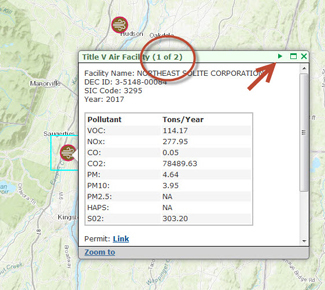
- View Title V permits and reports issued to facilities that are major sources of air emissions
- Locate hazardous waste treatment, storage and disposal facilities
- Activate the Public Fishing Rights layer to see your favorite fishing locations and nearby boat launches, then overlay information about the water quality of lakes, rivers, and streams to access DEC data for specific locations
- Find places to recreate
To access the mapping application, visit the [youtube http://youtube.com/w/?v=04XmO0trwac” title=”]. |

